Brits could face power cuts, travel chaos and rural communities cut off in an Arctic blast and here is the full list of places affected.
The UK is braced for “disruptive snow”, ice and cold temperatures over the coming days, the Met Office has said. Up to 20 centimetres of snow may accumulate in the worst affected areas in the country’s “first taste of winter”, according to the forecaster.
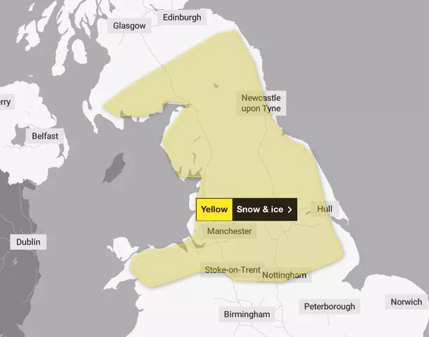
The Met Office has issued several yellow weather warnings for snow and ice for parts of the UK that began on Sunday afternoon and are in place until Tuesday morning, but said there is “potential” for warnings to be “escalated”.
On Monday, a warning comes into force at 7pm and is in place until 10am on Tuesday – covering areas in the East Midlands, Yorkshire, Wales and the north of England overnight.
Within the affected areas, there is a chance of power cuts, disruption to road and public transport and the risk of communities being cut off, the weather service said. “An area of snow may bring disruption to a central swathe of the UK during Monday night and Tuesday morning,” it states.

(
Met Office)
What should I expect?
- There is a small chance that power cuts will occur and other services, such as mobile phone coverage, may be affected
- A small chance that untreated pavements and cycle paths become impassable
- There is a slight chance that some rural communities could become cut off
- There is a slight chance that bus and train services may be delayed or cancelled, with some road closures and longer journey times
- A small chance of injuries from slips and falls on icy surfaces
- There is a small chance of travel delays on roads with some stranded vehicles and passengers, along with delayed or cancelled rail and air travel
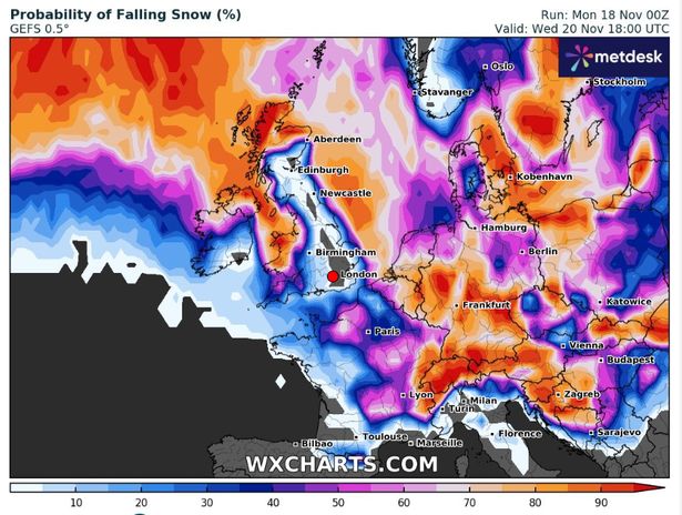
Tom Morgan, Met Office meteorologist, said: “We could see some disruptive snow in the Pennine regions, in particular, the Peak District as well, especially Monday night, but we could well see some impacts lasting on until Tuesday morning’s rush hour. Even down to lower levels, we could well see some snow as well, so quite a bit of disruption possible by Tuesday morning, and then the week ahead is likely to stay cold nationwide, a windy day on Tuesday, and then winter showers through the week ahead.”

(
WXCHARTS)
Mr Morgan said that despite a “mild” start to the month, the cold conditions are more typical of “mid-winter to late-winter”. He continued: “What we can say is that it’s going to be very cold for the time of year, there will be widespread overnight frosts, and a few locations where there’s snow on the ground.”
Here is a full list of the regions and local authorities affected by the yellow warning for ice running from 7pm tonight until 10am tomorrow.
East Midlands
- Derby
- Derbyshire
- Lincolnshire
- Nottingham
- Nottinghamshire
North East England
- Darlington
- Durham
- Gateshead
- Hartlepool
- Middlesbrough
- Newcastle upon Tyne
- North Tyneside
- Northumberland
- Redcar and Cleveland
- South Tyneside
- Stockton-on-Tees
- Sunderland
North West England
- Blackburn with Darwen
- Cheshire East
- Cheshire West and Chester
- Cumbria
- Greater Manchester
- Halton
- Lancashire
- Merseyside
- Warrington
SW Scotland, Lothian Borders
- Dumfries and Galloway
- Scottish Borders
Strathclyde
- South Lanarkshire
Wales
- Conwy
- Denbighshire
- Flintshire
- Gwynedd
- Wrexham
West Midlands
- Staffordshire
- Stoke-on-Trent
Yorkshire & Humber
- East Riding of Yorkshire
- Kingston upon Hull
- North East Lincolnshire
- North Lincolnshire
- North Yorkshire
- South Yorkshire
- West Yorkshire
- York
In southern England, a typical maximum temperature for this time of year is 11C, but daytime highs for the week ahead are forecast to be around 5C, while some parts of Scotland will reach “only just above freezing”, Mr Morgan added.
The meteorologist said the public can best prepare for the wintry weather by checking their cars are suitable for icy and potentially snowy conditions and to take extra supplies including food, blankets and a fully-charged mobile phone with them on journeys. He added that there was “likely” to be changes to the weather warnings in the coming days, and that “winter flurries” could be seen in the south of England later in the week.
Despite the cold conditions, the “whole of the UK” will enjoy more sunshine this week, the meteorologist added. He said: “There’ll be some snow showers in the peripheries of the UK, particularly northern Scotland, and down the east and the west coast, but if you live inland and you live in the south, there’ll be lots of sparkly blue skies on the most days through Tuesday to Friday.”
This post was originally published on here


