More than 119 million Americans are expected to travel an hour or more for the holidays between Saturday and New Year’s Day, either by car or by air, according to AAA. Of those, at least 2 million New Englanders are set to hit the highway locally to celebrate with friends and family.
With an active weather pattern across much of the country, New Englanders venturing out could encounter disruptive weather at some point during the big travel crunch leading up to Christmas and Hanukkah. Let’s break down where storms could impact your travels in New England and nationwide between now and Christmas Eve.
Southern New England
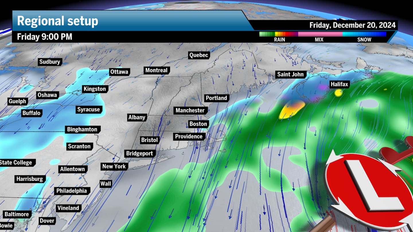
Friday: After a sunny Thursday, a low-pressure system lurks offshore Friday, but the bulk of precipitation will stay away. Only a few scattered rain or snow showers are expected from Cape Cod to Boston and west through Worcester. Flurries could fall at times across Western New England, including Vermont, the Berkshires, and into western Connecticut, but a coating of snow is expected at most. Travel impacts will be little to none.
Saturday: Cold air settles into the region under high pressure, setting up variable clouds and calm skies and clear roads. Afternoon highs will struggle and only reach the low 30s across Southern New England, including Boston, Worcester, Providence, Springfield, and Pittsfield. A few snow showers could hit coastal New England from the passing nearby system, but should be few and far between.
Sunday: Some flurries or snow showers may pop up across the region, but they should be brief. Seeing some of the coldest air this season, highs will really struggle to get out of the low 20s under dominant high pressure setting up a mostly dry day.
Monday: Staying calm across the region with mostly sunny skies while highs still remain below freezing, with afternoon highs in the mid-20s.
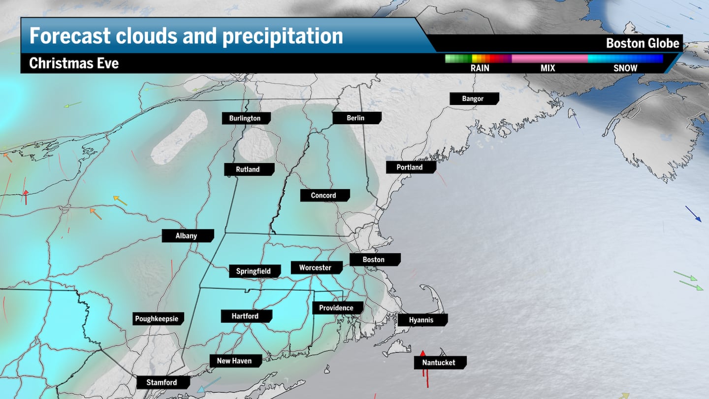
Christmas Eve: The strong high pressure begins to break down and slides to the east, keeping the area dry for most of the day, but still cold with temperatures slowly improving to the low 30s. Snow showers could work into the region in the afternoon, mainly from Worcester and Providence and areas west but could bring some brief snow into Boston in the evening.
Northern New England
Friday: Mostly cloudy with streaks of sunshine peaking through the clouds. A few flurries or light snow showers could work into the region with a system breaking down over the Great Lakes and New York as it infringes on Western New England. Highs will likely range from the upper 20s to the low 30s.
Saturday: A few light snow showers pop up across Maine on the backside of the offshore low that passes through Nova Scotia. This won’t be enough to disrupt travel but parts of I-95 from Augusta throughBangor could see a few flakes.
Sunday: A stray flurry could pop up, but it’ll be very isolated. High pressure builds into the region, pulling in some really frigid temperatures. Much of Vermont, New Hampshire, and Maine will be blanketed by highs stalling in the upper teens while coastal Maine cracks into the low 20s.
Monday: High pressure takes hold of the region and brings more sunshine into the picture, but temperatures will hardly improve. Highs will stay in the upper teens and low 20s across the northern half of the region.
Christmas Eve: Scattered light snow showers late in the day will bring a light coating to some spots and perhaps bring an inch or more for a nice white Christmas up north. The day stays cold with highs in the upper 20s and low 30s.
National trouble spots
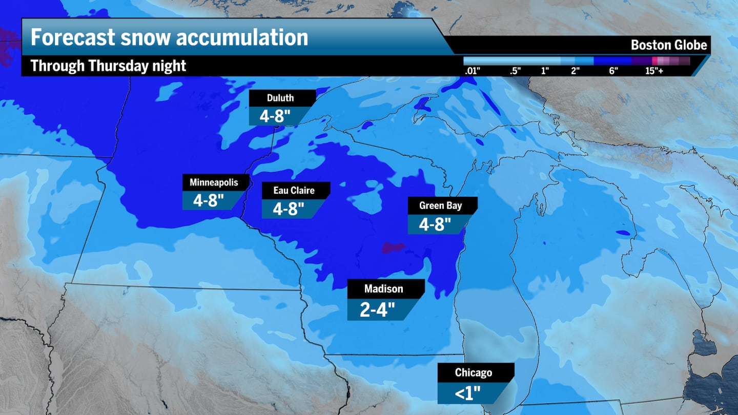
A quick-moving clipper storm will push into the Midwest Thursday and bring some accumulating snow across parts of Minnesota, Wisconsin, and into the Chicago metro area. The biggest snow totals are likely going to be across central and eastern Wisconsin, including Madison and Green Bay, where 5 to 8 inches could be possible. This storm will lose steam as it progresses into the Chicago area, but the city could see about an inch through Thursday evening.
On Friday, a weakening system will bring more snow, but not as heavy, across the Midwest, particularly across Chicago and Indianapolis.
The weekend stays calm under high pressure, though it’ll be quite cold. The next chance for any disruptive weather will come Monday from a system bringing light snow showers stretching from Minneapolis through Wisconsin and into the Detroit metro area during the day. Christmas Eve should be quiet.
Northeast/Mid-Atlantic
A weak system out of the Great Lakes could bring some light snow across Central and Western New York on Friday. Some lake effect snow could be in the mix along I-90 between Buffalo and Erie but with only an inch or two piling up. A few rain showers could make for some slick travel for those driving along the I-95 corridor to New York City, Philadelphia or Washington, D.C.
Otherwise, Saturday through Monday should stay mostly calm under the influence of high pressure building into the region, with colder than average temps for this time of year. On Christmas Eve, the Mid-Atlantic stays quiet but a few light snow showers could pop up across Western New York and parts of Pennsylvania, though there won’t be much in terms of accumulation and the roadways should stay in decent shape.
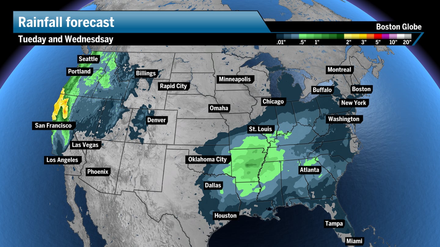
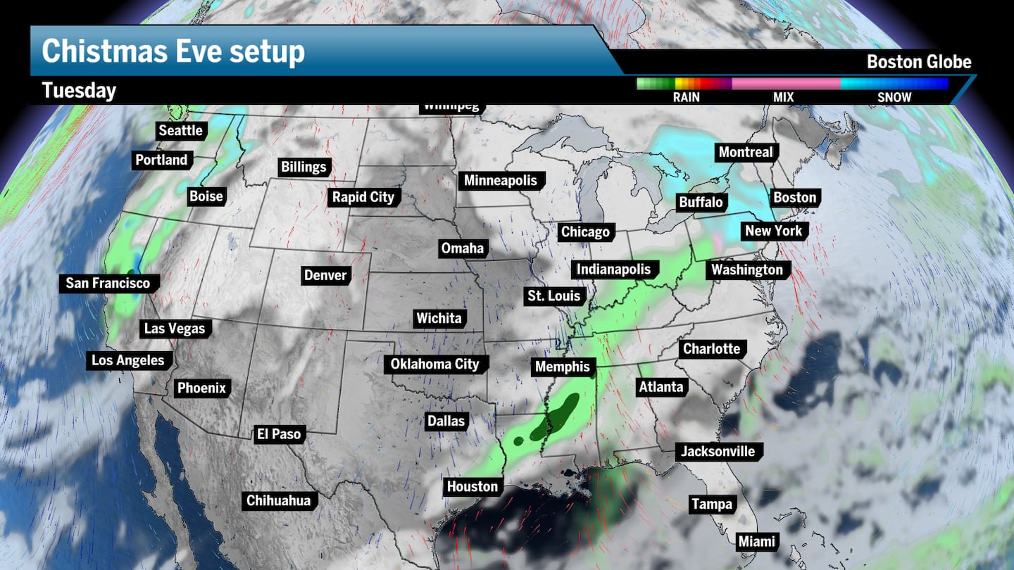
A moderate atmospheric river event will kickoff Saturday and last through Christmas Eve, bringing multiple systems packing coastal rain, mountain snow, and some wind conditions from Seattle to San Francisco. I would imagine some delays here with four separate fronts pushing into the region. The cities should just see rain with some pockets of heavier rain at times while the mountain passes will see snow fall with these storms.
The Plains
The middle part of the country will stay quiet for much of this stretch until Christmas Eve when a low pressure system begins to develop mostly likely over the Central and Southern Plains. This could bring some widespread rain across northeast Texas through Eastern Oklahoma and into parts of Arkansas and Missouri. With the area running pretty warm, there could be the chance for thunderstorms to develop as well, which could cause some delays with evening arrivals in St. Louis, Oklahoma City, and/or Kansas City.
Decent weather
The southeast will be relatively calm during this stretch, with really only a few light showers popping up across parts of Florida Sunday through Tuesday. It should be all clear outside of the volume of people traveling through the Atlanta and Miami airport hubs.
The southwest region of the country will miss much of the precipitation from the atmospheric river up north until the final front pushes into Southern California on Christmas Eve. LAX might see a few delays should some heavier storm cells push in and bring heavy rainfall, but impacts from Tuesday’s system should remain minor.
Sign up here for our daily Globe Weather Forecast that will arrive straight into your inbox bright and early each weekday morning.
Ken Mahan can be reached at [email protected]. Follow him on Instagram @kenmahantheweatherman.
This post was originally published on here


